Endurance-kaptajn Frank Worsley, Shackletons begavede navigatør, vidste, hvordan man holdt kursen

Frank Worsley, Ernest Shackletons navigatør, beregnede sin position og kortlagde kurser for at redde hele besætningen, på trods af frysende, blæsende, gennemblødte forhold på små både, der kastede i det sydlige Ocean. Kredit:Samtalen
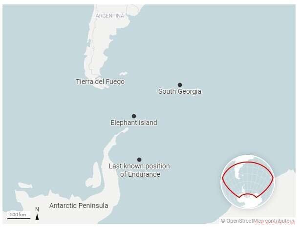
Da vraget af Ernest Shackletons skib Endurance blev fundet næsten 10.000 fod under overfladen af Antarktis Weddell Sea i marts 2022, var det placeret kun 4 miles fra sin sidst kendte position, som registreret af Endurances kaptajn og navigatør, Frank Worsley, i november 1915.
Det er en forbløffende grad af nøjagtighed for en position bestemt med mekaniske værktøjer, boglængde tabeller med referencenumre og pen og papir.
Ekspeditionen, der ledte efter skibet, havde søgt i et undersøisk område på 150 kvadratkilometer - en cirkel på 14 miles på tværs. Ingen vidste, hvor præcis Worsleys positionsberegning havde været, eller hvor langt skibet kunne have rejst, mens det sank.
Men som historiker af Antarktis udforskning var jeg ikke overrasket over at finde ud af, hvor nøjagtig Worsley var, og jeg forestiller mig, at de, der søgte efter vraget, heller ikke var det.
Navigation var nøglen
The Endurance havde forladt England i august 1914, hvor ireren Shackleton håbede på at blive den første til at krydse det antarktiske kontinent fra den ene side til den anden.
Men de landede aldrig engang på Antarktis. Skibet sad fast i havisen i Weddellhavet i januar 1915, og tvang mændene fra skibet ind i telte, der var slået op på det frosne hav i nærheden. Isens kraft knuste langsomt Endurance, sænkede den 10 måneder senere og satte gang i, hvad der ville blive en utrolig – og næsten utrolig – saga om overlevelse og navigation af Shackleton og hans besætning.
Shackletons eget lederskab er blevet legende, ligesom hans forpligtelse til at sikre, at ikke en mand gik tabt fra gruppen under hans kommando - selvom tre medlemmer af ekspeditionens 10-mands gruppe i Rosshavet omkom.
Mindre kendt er vigtigheden af navigationsevnerne hos den 42-årige Worsley, en newzealænder, der havde tilbragt årtier i den britiske handelsflåde og Royal Navy Reserve. Uden ham ville historien om Shackletons overlevelse sandsynligvis have været meget anderledes.
Markeringstid
Navigation kræver at bestemme et skibs placering i bredde- og længdegrad. Breddegrad er let at finde fra Solens vinkel over horisonten ved middagstid.
Længdegrad krævede at sammenligne den lokale middag - det øjeblik, hvor Solen var på sit højeste punkt - med den faktiske tid på et andet sted, hvor længdegraden allerede var kendt. Nøglen var at sikre, at tidsmålingen for den anden placering var nøjagtig.
At lave disse astronomiske observationer og lave de resulterende beregninger var svært nok på landjorden. På havet, med få faste landpunkter synlige, midt i dårligt vejr, var det næsten umuligt.
Så navigationen var i høj grad afhængig af "død regning". Dette var processen med at beregne et fartøjs position ved hjælp af en tidligere bestemt position og inkorporere estimater af, hvor hurtigt og hvilken vej skibet bevægede sig. Worsley kaldte det "sømandens beregning af kurser og afstand."
Sigter mod land
When the Endurance was crushed, the crew had to get themselves to safety, or die on an ice floe adrift somewhere in the Southern Ocean. In April 1916, six months after the Endurance sank, the sea ice on which they had camped began to break up. The 28 men and their remaining gear and supplies loaded into three lifeboats—the James Caird, Dudley Docker and Stancomb Wills—each named for major donors to the expedition.
Worsley was in charge of getting them to land. As the journey began, Shackleton "saw Worsley, as navigating officer, balancing himself on the gunwale of the Dudley Docker with his arm around the mast, ready to snap the sun. He got his observation and we waited eagerly while he worked out the sight."
To do that, he compared his measurement with the time on his chronometer and written tables of calculations.
And so began one of the most remarkable rescue missions in history. In a small open lifeboat, six men sailed 800 miles across some of the roughest seas on the planet to get help. We think they navigated with these instruments, on display in #PolarWorlds pic.twitter.com/4lxgzfR1BL
— Dr. Claire Warrior (@ClaireWarrior1) March 9, 2022
A last hope of survival
Once they managed to arrive on a little rocky strip called Elephant Island, off the coast of the Antarctic Peninsula, they still faced starvation. Shackleton believed that the only hope of survival lay in fetching help from elsewhere.
Worsley was ready. Before the Endurance was crushed, he had "worked out the courses and distances from the South Orkneys to South Georgia, the Falklands and Cape Horn, respectively, and from Elephant Island to the same places," he recalled in his memoir.
The men used parts of the other lifeboats to reinforce the James Caird for a long sea journey. Every day, Worsley "watched closely for the sun or stars to appear, to correct my chronometer, on the accuracy of which our lives and the success of the journey would depend."
On April 24, 1916, Worsley got "The first sunny day with a clear enough horizon to get a sight for rating my chronometer." That same day, he, Shackleton and four other men set off under sail in the 22.5-foot James Caird, carrying Worsley's chronometer, navigational books and two sextants, used for fixing the position of the Sun and stars.
The boat journey
These men, in this tiny boat, were going from one pinpoint of rock in the Southern Ocean to another, facing high winds, massive currents and choppy waters that could push them wildly astray or even sink them. The success of this voyage depended on Worsley's absolute accuracy, based on observations and estimations he made in the worst possible environmental conditions, while sleep-deprived and frostbitten.
They spent 16 days of "supreme strife amid heaving waters," as the boat sailed through some of the most dangerous sea conditions in the world, experiencing "mountainous" swells, rain, snow, sleet and hail. During that time, Worsley was able to get just four solid fixes on the boat's position. The rest was "a merry jest of guesswork" to determine where the wind and waves had taken them, and adjusting the steering accordingly.
The stakes were enormous—if he missed South Georgia, the next land was South Africa, 3,000 miles farther across more open ocean.
As Worsley wrote later:"Navigation is an art, but words fail to give my efforts a correct name. … Once, perhaps twice, a week the sun smiled a sudden wintry flicker, through storm-torn cloud. If ready for it, and smart, I caught it. The procedure was:I peered out from our burrow—precious sextant cuddled under my chest to prevent seas from falling on it. Sir Ernest stood by under the canvas with chronometer, pencil, and book. I shouted "Stand by," and knelt on the thwart—two men holding me up on either side. I brought the sun down to where the horizon ought to be and as the boat leaped frantically upward on the crest of a wave, snapped a good guess at the altitude and yelled "Stop." Sir Ernest took the time and I worked out the result. Then the fun started! Our fingers were so cold that he had to interpret his wobbly figures—my own so illegible that I had to recognize them by feats of memory."
On May 8, they saw floating seaweed and birds, and then spotted land. But they had arrived at South Georgia amid a hurricane, and for two days had to fight being driven by wind onto an island they had spent weeks desperately trying to reach.
Finally, they came ashore. Three of the six men, including Worsley, hiked across unmapped mountains and glaciers to reach a small settlement. Worsley joined a rescue boat back to get the other three. Shackleton later arranged a ship to collect the rest of the men from Elephant Island, all of whom had survived their own unimaginable hardships.
But the key to all of it, and indeed the recent discovery of the Endurance's wreck, was how Worsley had fought desperate conditions and still repeatedly managed to figure out where they were, where they were going and how to get there.
 Varme artikler
-
 Kan WhatsApp redde forhold?Kredit:Pixabay/CC0 Public Domain Mens unge mennesker blev født ind i den digitale verden, har ældre generationer været nødt til at lære at tilpasse sig den. En sådan alderskohorte er generation X (
 -
 Undersøgelse viser, at ledere skal tilpasse deres ledelsesstil under en kriseKredit:CC0 Public Domain Ny Curtin University-ledet forskning har fundet ud af, at chefer skal tilpasse deres lederskabsstil, når de håndterer en krise, for at sikre, at deres medarbejdere føler s
 -
 Jurassic fossil viser, hvordan tidlige pattedyr kunne sluge som deres moderne efterkommereFossilet af Microdocodon gracilis er bevaret i to klippeplader, og består af en hoveddel (PMOL-AM00025A, venstre) og en moddel (PMOL-AM00025B, ret). Det blev fundet på et sted nær landsbyen Wuhua i Da
 -
 5, 000 år gammel æggejagt:Forskning afslører overraskende kompleksitet ved handel med gamle strud…Et dekoreret æg fra Isis-graven, Vulci, Italien. Kredit:© Tamar Hodos, University of Bristol (med tilladelse fra Trustees of the British Museum) Et internationalt team af specialister, ledet af Un
- Sådan finder du afstanden mellem to punkter på en Circle
- Verdens sydligste træ vokser på et af de mest blæsende steder på jorden, men klimaforandringerne…
- Ny metode til fjernføling af iskappens underjordiske temperatur demonstreret
- Zinkoxid nanotråde:Ny løsning til billigere, renere produktion af elektroniske komponenter
- Satellitter giver os et overordnet syn på Jordens kulstofcyklus
- Påvirker tætheden den hastighed, som en væske fryser på?


